
The 50 Year Storm Is About To Hit Bells… Watch It LIVE
We've spent over 50 years at Bells Beach, and we can honestly say... the 50 Year Storm is coming. Only this time it'll be LIVE, straight from the Rip Curl Pro Bells Beach.
Thus far the waiting period for the 2019 Rip Curl Pro Bells Beach has not been great; we’ve seen medium-sized swell, mediocre winds and an inconsistent, small Bells Bowl. Sure, the world’s best have battled it out in Rounds 1 and 2 around the cliff at Winki… which was contestable and viewable… but we haven’t seen the Bowl at its best.
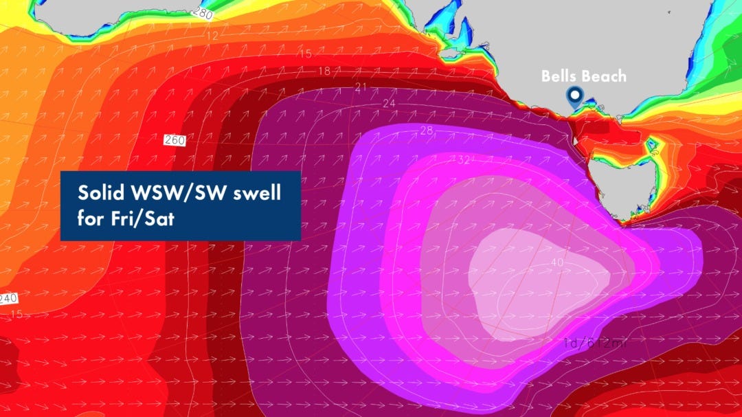
Until now. As the last three days of the waiting period approach we are seeing the start of what could be the best Bells we’ve seen since 1981… or 2006… those BIG years, where the wild Victorian coastline offered up long lines and powerful, rugged swell. The stars have aligned, the charts are becoming more and more clear, and from the looks of things the ocean is about to deliver.
Tune in to the final three days of the 2019 Rip Curl Pro Bells Beach. It will be ON, it will be BIG, and in the 50th year of surfing at Rip Curl, it will be one for the books.
The Official Surfline Forecast
THURSDAY 25th
4-6’ faces, building PM. Offshore WNW winds through the day.
SWELL: Holding WSW/SW swell early. Long-period new WSW/SW swell builds PM.
WIND:Moderate offshore WNW winds through the day.
FRIDAY 26th
8-12’ faces early, 12-15’+ faces PM. Side-offshore WSW winds in the morning, trending WSW/SW for the afternoon.
SWELL: Solid new WSW/SW swell-mix is on the rise, peaking late.
WIND: Moderate+ side-offshore WSW wind early trending sideshore WSW/SW and building through the day.
SATURDAY 27th
8-12’ faces early, easing PM. Offshore W winds through the day.
SWELL: Solid WSW/SW swell continues.
WIND: Moderate offshore W winds through the day.
Forecast Analysis
Broad-angled WSW trending SW swell (250-200) lingers into Thursday morning. Surf is in the shoulder- to head-high range early with sets overhead. New long-period WSW/SW swell (240-220) has size trending up through the day, sets going 2-3’ overhead in the afternoon. Moderate offshore WNW winds all day.
A stronger low developing in the South Indian Ocean passes by to the south of WA overnight, taking a great track to the east/northeast towards Tasmania Thursday into Friday. We are of high confidence that will deliver significant WSW/SW swell (240-200) building all day Friday, with a peak likely late. Surf in the double overhead range (8-12’ faces) prevails in the morning, building into the 3x overhead range (12-15’+ faces) that afternoon. Larger sets in the 4x overhead range (18-20’ faces) are likely through the back half of the afternoon as the swell approaches a peak Friday evening. Strong surf in the double overhead+ range continues into Saturday morning before easing.
Winds will be stronger on Friday, with moderate WSW winds early going WSW/SW and building for the afternoon. The slight southerly trend in wind Friday afternoon/evening in response to the low delivering the solid swell passing just to the south of Tasmania. Moderate W winds are favored to return on Saturday.
